Wachtwoord kwijt? Nieuwe gebruiker? Registeren
Lizard fish, Philippines. Photo by Stephane Rochon.
Enjoy and contribute!
| Zoek de beste duiklocaties |
|
|
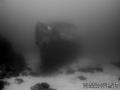
 Imperial Eagle MV
Malta, Malta island
Dit is een interactieve kaart! Gebruik "controls" voor pan and zoom op deze kaart.
|
Datum: WGS84 [ Help ] |
Breedtegraad: 35° 57.096' N |
Gebruiker beoordeling (1)
- Duiklog toevoegen
- Toevoegen aan mijn duiklocaties
- Comments (0)
- Duiklogs (1)
- trips (1)
- Foto's (4)
- Video's (0)
- Deel
- Favoriet
-
Je favoriete and toekomst duiklocatie lijst
Toegang
|
Hoe? Per boot Afstand Goede aanvaartijd (tot 30min) gemakkelijk te vinden? Gemakkelijk te vinden |
Duiklocatie Karakteristieken Characteristics
Alternative naam Imperial Eagle ferry
Gemiddelde diepte 35 m / 114.8 ft
max diepte 46 m / 150.9 ft
Stroming Traag
Zicht Goed ( 10 - 30 m)
Kwaliteit
Duiklocatie kwaliteit Geweldig
Ervaring CMAS ** / AOW
Bio interest Interessant
Meer details
Week drukte
Weekend drukte
Duik type
- Wrak
Duiklocatie activiteiten
- Duik training
- Fotografie
Gevaren
- Diepte
Aanvullende informatie
English (vertaal deze tekst in Nederlands): The Imperial Eagle was one of the ferryboats connecting Malta and Gozo.
The hull, in navigation trim, lays on a sandy bottom at a depth of -42m, 300m North-East of Qwara Point.
Auteur: Vladimir Dunaev Inzenders (1) Zij doken op deze locatie ! (6)
 Foto's

Imperial Eagle MV |

Imperial Eagle MV |

Imperial Eagle MV |
Imperial Eagle MV |
Comments
Wees de eerste en becommentarieer dit land
Fouten, Feedback
Je kunt deze pagina gebruiken om fouten te herstellen of nieuwe info toe te voegen. Als je problemen hebt met deze pagina, Stuur ons feedback.
Adverteer
Wannadive.net 24/24
Wannadive.net op jouw mobiel
![]()
RSS Alle RSS feeds van Wannadive.net
Nieuwsbrief Alle nieuws per E-mail