Wachtwoord kwijt? Nieuwe gebruiker? Registeren
Clownfish, Philippines. Photo by Stephane Rochon.
Enjoy and contribute!
| Zoek de beste duiklocaties |
|
|
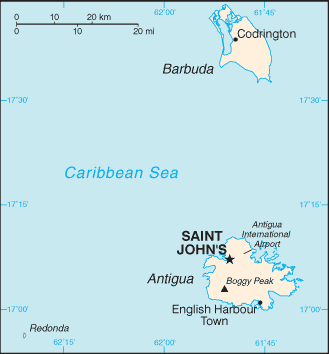
 Antigua and Barbuda
Centraal-Amerika
Locatie: Caribbean, islands between the Caribbean Sea and the North Atlantic Ocean, east-southeast of Puerto Rico
Geografische coordinaten: 17° 3' N, 61° 48' W
Kustlijn km: 153 km km
Klimaat: tropical maritime; little seasonal temperature variation
Terrein: mostly low-lying limestone and coral islands, with some higher volcanic areas
Hoogte: lowest point: Caribbean Sea 0 m
highest point: Boggy Peak 402 m
Natuurlijke gevaren: hurricanes and tropical storms (July to October); periodic droughts
Valuta: East Caribbean dollar (XCD)
Populatie: 69,481 (July 2007 est.)
Talen: English (official), local dialects
Hoofdstad: Saint John's
Provincies: 6 parishes and 2 dependencies*; Barbuda*, Redonda*, Saint George, Saint John, Saint Mary, Saint Paul, Saint Peter, Saint Philip
Meer details
| Jan | Feb | Mar | Apr | May | Jun | Jul | Aug | Sep | Oct | Nov | Dec | |
|---|---|---|---|---|---|---|---|---|---|---|---|---|
| Climate | ||||||||||||
| Air temp. | ||||||||||||
| Water temp. | ||||||||||||
| Equipment | Je ne sais pas | Je ne sais pas | Je ne sais pas | Je ne sais pas | Je ne sais pas | Je ne sais pas | Je ne sais pas | Je ne sais pas | Je ne sais pas | Je ne sais pas | Je ne sais pas | Je ne sais pas |
| Best season | ||||||||||||
Extra kaart
Wil je info toevoegen over Antigua and Barbuda? Laat ons weten...
Dit is een interactieve kaart! Gebruik "controls" voor pan and zoom op deze kaart.

- Favoriet
-
Je favoriete and toekomst duiklocatie lijst
Je favoriete zone staat niet in het overzicht? Zone toevoegen
Zones
| Zones (1) | Duiklocatie | Sub zones |
|---|---|---|
| Antigua Island | 4 | 0 |
 Duiklogs
|
Comments
Fouten, Feedback
Als je nieuwe informatie wilt toevoegen of fouten van dit land wilt herstellen, Stuur ons feedback.
Adverteer
Wannadive.net 24/24
Wannadive.net op jouw mobiel
![]()
RSS Alle RSS feeds van Wannadive.net
Nieuwsbrief Alle nieuws per E-mail