Wachtwoord kwijt? Nieuwe gebruiker? Registeren
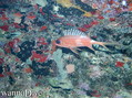
Lizard fish, Philippines. Photo by Stephane Rochon.
Enjoy and contribute!
| Zoek de beste duiklocaties |
|
|
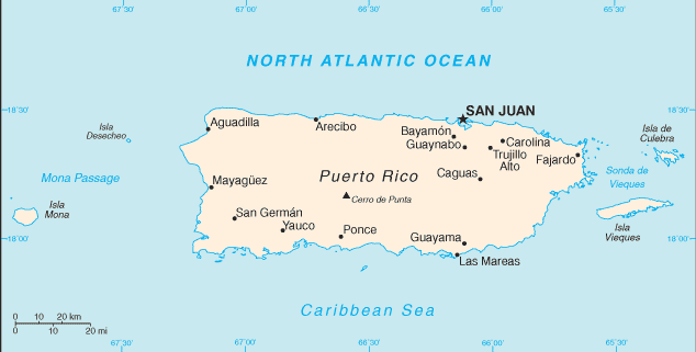
 Puerto Rico
Centraal-Amerika
Locatie: Caribbean, island between the Caribbean Sea and the North Atlantic Ocean, east of the Dominican Republic
Geografische coordinaten: 18° 15' N, 66° 30' W
Kustlijn km: 501 km km
Klimaat: tropical marine, mild; little seasonal temperature variation
Terrein: mostly mountains with coastal plain belt in north; mountains precipitous to sea on west coast; sandy beaches along most coastal areas
Hoogte: lowest point: Caribbean Sea 0 m
highest point: Cerro de Punta 1,339 m
Natuurlijke gevaren: periodic droughts; hurricanes
Valuta: US dollar (USD)
Populatie: 3,927,188 (July 2006 est.)
Talen: Spanish, English
Hoofdstad: San Juan
Provincies: none (territory of the US with commonwealth status); there are no first-order administrative divisions, but there are 78 municipalities (municipios, singular - municipio) at the second order; Adjuntas, Aguada, Aguadilla, Aguas Buenas, Aibonito, Anasco, Arecibo, Arroyo, Barceloneta, Barranquitas, Bayamon, Cabo Rojo, Caguas, Camuy, Canovanas, Carolina, Catano, Cayey, Ceiba, Ciales, Cidra, Coamo, Comerio, Corozal, Culebra, Dorado, Fajardo, Florida, Guanica, Guayama, Guayanilla, Guaynabo, Gurabo, Hatillo, Hormigueros, Humacao, Isabela, Jayuya, Juana Diaz, Juncos, Lajas, Lares, Las Marias, Las Piedras, Loiza, Luquillo, Manati, Maricao, Maunabo, Mayaguez, Moca, Morovis, Naguabo, Naranjito, Orocovis, Patillas, Penuelas, Ponce, Quebradillas, Rincon, Rio Grande, Sabana Grande, Salinas, San German, San Juan, San Lorenzo, San Sebastian, Santa Isabel, Toa Alta, Toa Baja, Trujillo Alto, Utuado, Vega Alta, Vega Baja, Vieques, Villalba, Yabucoa, Yauco
Meer details
| Jan | Feb | Mar | Apr | May | Jun | Jul | Aug | Sep | Oct | Nov | Dec | |
|---|---|---|---|---|---|---|---|---|---|---|---|---|
| Climate | ||||||||||||
| Air temp. | ||||||||||||
| Water temp. | ||||||||||||
| Equipment | Don't know | Don't know | Don't know | Don't know | Don't know | Don't know | Don't know | Don't know | Don't know | Don't know | Don't know | Don't know |
| Best season | ||||||||||||
Extra kaart
Wil je info toevoegen over Puerto Rico? Laat ons weten...
Dit is een interactieve kaart! Gebruik "controls" voor pan and zoom op deze kaart.
- Favoriet
-
Je favoriete and toekomst duiklocatie lijst
Je favoriete zone staat niet in het overzicht? Zone toevoegen
Zones
| Zones (5) | Duiklocatie | Sub zones |
|---|---|---|
| Culebra island | 6 | 0 |
| North and East | 14 | 0 |
| South East | 2 | 0 |
| Vieques island | 2 | 0 |
| West Coast and Mona Island | 6 | 0 |
Duiklocatie
| Duiklocatie (1) | Kwaliteit | Gem diepte | Max diepte | Ervaring | Duik type | ||
|---|---|---|---|---|---|---|---|
| Peñon de mera | 9 / - | 6.1 m | 12.2 m | Alle duikers | 

|
 Foto's

Punta Tamarindo Grande |

Punta Tamarindo Grande |
Punta Tamarindo Grande |

Cayo Icacos |
Duiklogs
|
Comments
Fouten, Feedback
Als je nieuwe informatie wilt toevoegen of fouten van dit land wilt herstellen, Stuur ons feedback.
Adverteer
Wannadive.net 24/24
Wannadive.net op jouw mobiel
![]()
RSS Alle RSS feeds van Wannadive.net
Nieuwsbrief Alle nieuws per E-mail