Wachtwoord kwijt? Nieuwe gebruiker? Registeren
Lizard fish, Philippines. Photo by Stephane Rochon.
Enjoy and contribute!
| Zoek de beste duiklocaties |
|
|
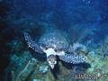
 Útila Island
Honduras, Bay Islands
English (vertaal deze tekst in Nederlands): Útila (Isla de Útila) is the third largest of Honduras' Bay Islands, after Roatán and Guanaja, in a region that marks the south end of the Mesoamerican Barrier Reef System, the second-largest in the world. The eastern end of the island is capped by a thin veneer of basaltic volcanic rocks, erupted from several pyroclastic cones including 74 m (243 ft) Pumpkin Hill which forms the highest point on the island. It has been documented in history since Columbus' fourth voyage, and currently enjoys growing tourism with emphasis on recreational diving.
Meer details
| Jan | Feb | Mar | Apr | May | Jun | Jul | Aug | Sep | Oct | Nov | Dec | |
|---|---|---|---|---|---|---|---|---|---|---|---|---|
| Climate | ||||||||||||
| Air temp. | ||||||||||||
| Water temp. | ||||||||||||
| Equipment | Nie wiem | Nie wiem | Nie wiem | Nie wiem | Nie wiem | Nie wiem | Nie wiem | Nie wiem | Nie wiem | Nie wiem | Nie wiem | Nie wiem |
| Best season | ||||||||||||
Dit is een interactieve kaart! Gebruik "controls" voor pan and zoom op deze kaart.
- Favoriet
-
Je favoriete and toekomst duiklocatie lijst
Duiklocatie
| Duiklocatie (21) | Kwaliteit | Gem diepte | Max diepte | Ervaring | Duik type | ||
|---|---|---|---|---|---|---|---|
| Airport Caves | - / - | 32.8 ft | 59.1 ft | Alle duikers | 
|
||
| Aquarium | - / - | 49.9 ft | 60 ft | CMAS * / OW |
|
||
| Black Corral Wall | - / - | 15.1 ft | 129.9 ft | Alle duikers | 

|
||
| Black Hills | 3 / - | 39.4 ft | 98.4 ft | Alle duikers | 

|
||
| Blackish Point | - / - | 49.2 ft | 85.3 ft | Alle duikers |
|
||
| CJ's Dropoff | - / - | 49.9 ft | 120.1 ft | Alle duikers |
|
||
| Duppy Waters | 1 / - | 49.2 ft | 98.4 ft | Alle duikers |
|
||
| Eagle Ray Alley | - / - | 49.2 ft | 78.7 ft | Alle duikers |
|
||
| Great Wall | - / - | 65.6 ft | 95.1 ft | CMAS * / OW |
|
||
| Halliburton | 2 / - | 88.6 ft | 101.7 ft | Alle duikers | 
|
||
| Jack's Bight | - / - | 20 ft | 65 ft | CMAS * / OW |
|
||
| Little Bight | - / - | 23 ft | 98.4 ft | Alle duikers |
|
||
| moon hole | - / - | 15.1 ft | 80.1 ft | Alle duikers |
|
||
| Old House | 2 / - | 49.2 ft | 131.2 ft | Alle duikers |
|
||
| Raggedy Cay | - / - | 49.2 ft | 98.4 ft | Alle duikers |
|
||
| Ships Stern | - / - | 49.2 ft | 82 ft | Alle duikers | 
|
||
| Silver Garden | - / - | 29.9 ft | 120.1 ft | Alle duikers |
|
||
| Sting Ray Point | - / - | 49.9 ft | 76.1 ft | Alle duikers | 
|
||
| Ted's Point West | - / - | 49.9 ft | 59.1 ft | Alle duikers |

|
||
| The Maze | - / - | 49.2 ft | 131.2 ft | CMAS * / OW |
|
||
| Utila Open Water | 1 / - | 9.8 ft | 49.2 ft | Alle duikers | 
|

 Comments
Wees de eerste en becommentarieer dit land
Fouten, Feedback
Je kunt deze pagina gebruiken om fouten te herstellen of nieuwe info toe te voegen. Als je problemen hebt met deze pagina, Stuur ons feedback.
Adverteer
Wannadive.net 24/24
Wannadive.net op jouw mobiel
![]()
RSS Alle RSS feeds van Wannadive.net
Nieuwsbrief Alle nieuws per E-mail