Dit is een interactieve kaart! Gebruik "controls" voor pan and zoom op deze kaart.
Gebruiker beoordeling (1)
Toegang
|
English (vertaal deze tekst in Nederlands): SW of Grand Bahama island: just W of Silver Point and E of Xanadu Beach, about 1.5 miles off the coast. Two permanent buoys mark the ship’s position (one at the bow and one at the stern).
English (vertaal deze tekst in Nederlands): SW of Grand Bahama island: just W of Silver Point and E of Xanadu Beach, about 1.5 miles off the coast. Two permanent buoys mark the ship’s position (one at the bow and one at the stern).
SW of Grand Bahama island: just W of Silver Point and E of Xanadu Beach, about 1.5 miles off the coast. Two permanent buoys mark the ship’s position (one at the bow and one at the stern).
English (vertaal deze tekst in Nederlands): SW of Grand Bahama island: just W of Silver Point and E of Xanadu Beach, about 1.5 miles off the coast. Two permanent buoys mark the ship’s position (one at the bow and one at the stern).
English (vertaal deze tekst in Nederlands): SW of Grand Bahama island: just W of Silver Point and E of Xanadu Beach, about 1.5 miles off the coast. Two permanent buoys mark the ship’s position (one at the bow and one at the stern).
English (vertaal deze tekst in Nederlands): SW of Grand Bahama island: just W of Silver Point and E of Xanadu Beach, about 1.5 miles off the coast. Two permanent buoys mark the ship’s position (one at the bow and one at the stern).
English (vertaal deze tekst in Nederlands): SW of Grand Bahama island: just W of Silver Point and E of Xanadu Beach, about 1.5 miles off the coast. Two permanent buoys mark the ship’s position (one at the bow and one at the stern).
English (vertaal deze tekst in Nederlands): SW of Grand Bahama island: just W of Silver Point and E of Xanadu Beach, about 1.5 miles off the coast. Two permanent buoys mark the ship’s position (one at the bow and one at the stern).
English (vertaal deze tekst in Nederlands): SW of Grand Bahama island: just W of Silver Point and E of Xanadu Beach, about 1.5 miles off the coast. Two permanent buoys mark the ship’s position (one at the bow and one at the stern).
Hoe? Per boot
Afstand Goede aanvaartijd (tot 30min)
gemakkelijk te vinden? Moeilijk te vinden
|
|
Duiklocatie Karakteristieken Characteristics
Alternative naam M/S Logna
Gemiddelde diepte 25 m / 82 ft
max diepte 31 m / 101.7 ft
Stroming Traag
Zicht Goed ( 10 - 30 m)
Kwaliteit
Duiklocatie kwaliteit Goed
Ervaring CMAS ** / AOW
Bio interest Geweldig
Meer details
Week drukte
Weekend drukte
Duik type
- Wrak
Duiklocatie activiteiten
- Fotografie
Gevaren
Aanvullende informatie
English (vertaal deze tekst in Nederlands): This 230 feet long vessel was built in Norway in 1954. It was intentionally sunk october 16, 1982. She now lays on her port side on a flat sandy floor, not far from few isolated coral banks.
English (vertaal deze tekst in Nederlands): This 230 feet long vessel was built in Norway in 1954. It was intentionally sunk october 16, 1982. She now lays on her port side on a flat sandy floor, not far from few isolated coral banks.
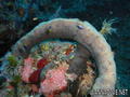
This 230 feet long vessel was built in Norway in 1954. It was intentionally sunk october 16, 1982. She now lays on her port side on a flat sandy floor, not far from few isolated coral banks.
English (vertaal deze tekst in Nederlands): This 230 feet long vessel was built in Norway in 1954. It was intentionally sunk october 16, 1982. She now lays on her port side on a flat sandy floor, not far from few isolated coral banks.
English (vertaal deze tekst in Nederlands): This 230 feet long vessel was built in Norway in 1954. It was intentionally sunk october 16, 1982. She now lays on her port side on a flat sandy floor, not far from few isolated coral banks.
English (vertaal deze tekst in Nederlands): This 230 feet long vessel was built in Norway in 1954. It was intentionally sunk october 16, 1982. She now lays on her port side on a flat sandy floor, not far from few isolated coral banks.
English (vertaal deze tekst in Nederlands): This 230 feet long vessel was built in Norway in 1954. It was intentionally sunk october 16, 1982. She now lays on her port side on a flat sandy floor, not far from few isolated coral banks.
English (vertaal deze tekst in Nederlands): This 230 feet long vessel was built in Norway in 1954. It was intentionally sunk october 16, 1982. She now lays on her port side on a flat sandy floor, not far from few isolated coral banks.
English (vertaal deze tekst in Nederlands): This 230 feet long vessel was built in Norway in 1954. It was intentionally sunk october 16, 1982. She now lays on her port side on a flat sandy floor, not far from few isolated coral banks.
 Comments
login om dit tool te gebruiken.
Nog geen account? Registreer eerst; it's free!
Alle tonen (2)...
Fouten, Feedback
Je kunt deze pagina gebruiken om fouten te herstellen of nieuwe info toe te voegen. Als je problemen hebt met deze pagina, Stuur ons feedback.
Wannadive.net 24/24
Wannadive.net op jouw mobiel

Nieuwsbrief Alle nieuws per E-mail
 Theo's Wreck

Door Theo Galanopoulos , 14-05-2010
Theo (From Theo's Wreck) - I Like the plaque... Thanks