Dit is een interactieve kaart! Gebruik "controls" voor pan and zoom op deze kaart.
Gebruiker beoordeling (0)
Toegang
|
English (vertaal deze tekst in Nederlands): From the entrance to Malakal Harbor just around the North pincher a few yards. Often a mooring line on her
English (vertaal deze tekst in Nederlands): From the entrance to Malakal Harbor just around the North pincher a few yards. Often a mooring line on her
From the entrance to Malakal Harbor just around the North pincher a few yards. Often a mooring line on her
English (vertaal deze tekst in Nederlands): From the entrance to Malakal Harbor just around the North pincher a few yards. Often a mooring line on her
English (vertaal deze tekst in Nederlands): From the entrance to Malakal Harbor just around the North pincher a few yards. Often a mooring line on her
English (vertaal deze tekst in Nederlands): From the entrance to Malakal Harbor just around the North pincher a few yards. Often a mooring line on her
English (vertaal deze tekst in Nederlands): From the entrance to Malakal Harbor just around the North pincher a few yards. Often a mooring line on her
English (vertaal deze tekst in Nederlands): From the entrance to Malakal Harbor just around the North pincher a few yards. Often a mooring line on her
English (vertaal deze tekst in Nederlands): From the entrance to Malakal Harbor just around the North pincher a few yards. Often a mooring line on her
Hoe? Per boot
Afstand Korte aanvaartijd (tot 10min)
gemakkelijk te vinden? Gemakkelijk te vinden
|
|
Duiklocatie Karakteristieken Characteristics
Gemiddelde diepte 27 m / 88.6 ft
max diepte 41 m / 134.5 ft
Stroming Traag
Zicht Medium ( 5 - 10 m)
Kwaliteit
Duiklocatie kwaliteit Geweldig
Ervaring Alle duikers
Bio interest Interessant
Meer details
Week drukte
Weekend drukte
Duik type
- Wrak
Duiklocatie activiteiten
- Biologie
- Nachtduik
- Duik training
- Fotografie
Gevaren
Aanvullende informatie
English (vertaal deze tekst in Nederlands): 502 Foot length, 66 Foot beam
10,000 Ton, Combined Fleet Tanker
Stinging Hydroids cover the marker buoy line to the ship.
She was attacked by aircraft from the Carrier Enterprise as part of Task Force 58, Operation Desecrate One, on March 30 and finished off the later that day by aircraft from the same Carrier .
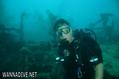
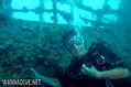
502 Foot length, 66 Foot beam
10,000 Ton, Combined Fleet Tanker
Stinging Hydroids cover the marker buoy line to the ship.
She was attacked by aircraft from the Carrier Enterprise as part of Task Force 58, Operation Desecrate One, on March 30 and finished off the later that day by aircraft from the same Carrier .
English (vertaal deze tekst in Nederlands): 502 Foot length, 66 Foot beam
10,000 Ton, Combined Fleet Tanker
Stinging Hydroids cover the marker buoy line to the ship.
She was attacked by aircraft from the Carrier Enterprise as part of Task Force 58, Operation Desecrate One, on March 30 and finished off the later that day by aircraft from the same Carrier .
 Comments
login om dit tool te gebruiken.
Nog geen account? Registreer eerst; it's free!
Alle tonen (0)...
Wees de eerste en becommentarieer dit land
Fouten, Feedback
Je kunt deze pagina gebruiken om fouten te herstellen of nieuwe info toe te voegen. Als je problemen hebt met deze pagina, Stuur ons feedback.
Wannadive.net 24/24
Wannadive.net op jouw mobiel

Nieuwsbrief Alle nieuws per E-mail
 Amatsu Maru