Wachtwoord kwijt? Nieuwe gebruiker? Registeren
Clownfish, Philippines. Photo by Stephane Rochon.
Enjoy and contribute!
| Zoek de beste duiklocaties |
|
|
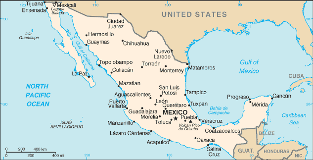
 Mexico
Centraal-Amerika
Locatie: Middle America, bordering the Caribbean Sea and the Gulf of Mexico, between Belize and the US and bordering the North Pacific Ocean, between Guatemala and the US
Geografische coordinaten: 23° 0' N, 102° 0' W
Kustlijn km: 9,330 km km
Klimaat: varies from tropical to desert
Terrein: high, rugged mountains; low coastal plains; high plateaus; desert
Hoogte: lowest point: Laguna Salada -10 m
highest point: Volcan Pico de Orizaba 5,700 m
Natuurlijke gevaren: tsunamis along the Pacific coast, volcanoes and destructive earthquakes in the center and south, and hurricanes on the Pacific, Gulf of Mexico, and Caribbean coasts
Valuta: Mexican peso (MXN)
Populatie: 106,202,903 (July 2005 est.)
Talen: Spanish, various Mayan, Nahuatl, and other regional indigenous languages
Hoofdstad: Mexico
Provincies: 31 states and 1 federal district* ; Aguascalientes, Baja California, Baja California Sur, Campeche, Chiapas, Chihuahua, Coahuila de Zaragoza, Colima, Distrito Federal*, Durango, Guanajuato, Guerrero, Hidalgo, Jalisco, Mexico, Michoacan de Ocampo, Morelos, Nayarit, Nuevo Leon, Oaxaca, Puebla, Queretaro de Arteaga, Quintana Roo, San Luis Potosi, Sinaloa, Sonora, Tabasco, Tamaulipas, Tlaxcala, Veracruz-Llave, Yucatan, Zacatecas
Meer details
| Jan | Feb | Mar | Apr | May | Jun | Jul | Aug | Sep | Oct | Nov | Dec | |
|---|---|---|---|---|---|---|---|---|---|---|---|---|
| Climate | ||||||||||||
| Air temp. | ||||||||||||
| Water temp. | ||||||||||||
| Equipment | ||||||||||||
| Best season | ||||||||||||
Extra kaart
Wil je info toevoegen over Mexico? Laat ons weten...
Dit is een interactieve kaart! Gebruik "controls" voor pan and zoom op deze kaart.

- Favoriet
-
Je favoriete and toekomst duiklocatie lijst
Je favoriete zone staat niet in het overzicht? Zone toevoegen
Zones
| Zones (9) | Duiklocatie | Sub zones |
|---|---|---|
| Baja California | 48 | 5 |
| Capital Region | 2 | 1 |
| Central Highlands | 2 | 0 |
| Central Pacific | 24 | 3 |
| Islas Revillagigedos | 6 | 0 |
| Northeast - Monterrey | 1 | 0 |
| Northwest - Sinaloa & Sonora | 35 | 3 |
| Southern Gulf of Mexico | 10 | 1 |
| Yucatán Peninsula | 123 | 9 |


 Duiklogs
|
Duiktrips
|
Comments
Door schris , 11-04-2018
Use wannadive zone download link - There are only two dive site for now in this area; you can download them from https://www.wannadive.net/spot/Central_America/Mexico/Baja_California/La_Paz___Isla_Partida/ See the download link and click on the available output format.
Door dfb72es , 10-04-2018
COORDENADAS GPS - HOLA A TODOS, ESTOY EN LA BÚSQUEDA DE COORDENADAS GPS DE TODO LO QUE ESTE SUMERGIDO EN LA ZONA DE LA PAZ BCS MX.
GRACIAS
Fouten, Feedback
Als je nieuwe informatie wilt toevoegen of fouten van dit land wilt herstellen, Stuur ons feedback.
Adverteer
Wannadive.net 24/24
Wannadive.net op jouw mobiel
![]()
RSS Alle RSS feeds van Wannadive.net
Nieuwsbrief Alle nieuws per E-mail