Wachtwoord kwijt? Nieuwe gebruiker? Registeren
Lizard fish, Philippines. Photo by Stephane Rochon.
Enjoy and contribute!
| Zoek de beste duiklocaties |
|
|
 Dirt Island
USA, Oregon
Dit is een interactieve kaart! Gebruik "controls" voor pan and zoom op deze kaart.
|
Datum: WGS84 [ Help ] |
Breedtegraad: 44° 4.899' N |
Gebruiker beoordeling (0)
- Duiklog toevoegen
- Toevoegen aan mijn duiklocaties
- Comments (0)
- Duiklogs (0)
- trips (0)
- Foto's (2)
- Video's (0)
- Deel
- Favoriet
-
Je favoriete and toekomst duiklocatie lijst
Toegang
|
English (vertaal deze tekst in Nederlands): Head east on Hwy 126, turn right at Cougar Dam Rd/Natl Forest Develop Road 19 Rd, Slight right at Aufderheide Dr go about 3 miles , Slight right to stay on Aufderheide Dr go about 100 ft., Turn right to stay on Aufderheide Dr go 6.3 miles, Turn left at Natl Forest Develop Road 500 Rd go 1.1 miles, Continue until you find south boat ramp. Hoe? Per boot Afstand Korte aanvaartijd (tot 10min) gemakkelijk te vinden? Gemakkelijk te vinden |
Duiklocatie Karakteristieken Characteristics
Gemiddelde diepte 12.2 m / 40 ft
max diepte 39.6 m / 129.9 ft
Stroming Traag
Zicht Slecht
Kwaliteit
Duiklocatie kwaliteit Standaard
Ervaring CMAS ** / AOW
Bio interest Arm
Meer details
Week drukte
Weekend drukte
Duik type
- Zoetwater
- Muur
- Diep
Duiklocatie activiteiten
Gevaren
- Diepte
- Boot verkeer
Aanvullende informatie
English (vertaal deze tekst in Nederlands): The west side of the island declines to 40 feet, then a wall down to 130 and a flat landing at 130. The visibility can vary due to small current and dirt. This is an advanced dive.
Auteur: Scubastu01 Inzenders (1) Zij doken op deze locatie ! (1)
 Foto's
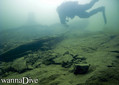
Dirt Island |
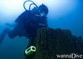
Dirt Island |
Comments
Wees de eerste en becommentarieer dit land
Fouten, Feedback
Je kunt deze pagina gebruiken om fouten te herstellen of nieuwe info toe te voegen. Als je problemen hebt met deze pagina, Stuur ons feedback.
Adverteer
Wannadive.net 24/24
Wannadive.net op jouw mobiel
![]()
RSS Alle RSS feeds van Wannadive.net
Nieuwsbrief Alle nieuws per E-mail