Dit is een interactieve kaart! Gebruik "controls" voor pan and zoom op deze kaart.
Gebruiker beoordeling (0)
Toegang
|
English (vertaal deze tekst in Nederlands): Jeffreys Ledge is a large glacially-created feature, stretching 33 miles from offshore of Rockport, MA to Cape Elizabeth, ME. Dive charters departing from Gloucester run special trips upon request.
English (vertaal deze tekst in Nederlands): Jeffreys Ledge is a large glacially-created feature, stretching 33 miles from offshore of Rockport, MA to Cape Elizabeth, ME. Dive charters departing from Gloucester run special trips upon request.
Jeffreys Ledge is a large glacially-created feature, stretching 33 miles from offshore of Rockport, MA to Cape Elizabeth, ME. Dive charters departing from Gloucester run special trips upon request.
English (vertaal deze tekst in Nederlands): Jeffreys Ledge is a large glacially-created feature, stretching 33 miles from offshore of Rockport, MA to Cape Elizabeth, ME. Dive charters departing from Gloucester run special trips upon request.
English (vertaal deze tekst in Nederlands): Jeffreys Ledge is a large glacially-created feature, stretching 33 miles from offshore of Rockport, MA to Cape Elizabeth, ME. Dive charters departing from Gloucester run special trips upon request.
English (vertaal deze tekst in Nederlands): Jeffreys Ledge is a large glacially-created feature, stretching 33 miles from offshore of Rockport, MA to Cape Elizabeth, ME. Dive charters departing from Gloucester run special trips upon request.
English (vertaal deze tekst in Nederlands): Jeffreys Ledge is a large glacially-created feature, stretching 33 miles from offshore of Rockport, MA to Cape Elizabeth, ME. Dive charters departing from Gloucester run special trips upon request.
English (vertaal deze tekst in Nederlands): Jeffreys Ledge is a large glacially-created feature, stretching 33 miles from offshore of Rockport, MA to Cape Elizabeth, ME. Dive charters departing from Gloucester run special trips upon request.
English (vertaal deze tekst in Nederlands): Jeffreys Ledge is a large glacially-created feature, stretching 33 miles from offshore of Rockport, MA to Cape Elizabeth, ME. Dive charters departing from Gloucester run special trips upon request.
Hoe? Per boot
Afstand Lange aanvaartijd (> 30min)
gemakkelijk te vinden? Moeilijk te vinden
|
|
Duiklocatie Karakteristieken Characteristics
Gemiddelde diepte 36.6 m / 120.1 ft
max diepte 36.6 m / 120.1 ft
Stroming Medium ( 1-2 knopen)
Zicht Heel goed ( > 30 m)
Kwaliteit
Duiklocatie kwaliteit Geweldig
Ervaring CMAS ** / AOW
Bio interest Geweldig
Meer details
Week drukte
Weekend drukte
Duik type
- Drift duik
- Grote vissen
Duiklocatie activiteiten
- Biologie
Gevaren
- Diepte
- Stroming
- Netten
Aanvullende informatie
English (vertaal deze tekst in Nederlands): On the northern edge of NOAA's Stellwagen Bank National Marine Sanctuary, rocky ridges on the southern edge of Jeffreys Ledge rise to within 115 feet of the surface. The shallowest portion of the ledge is comprised of piled cobble and boulders. Anemones, stalked tunicates, and coralline algae reside on the rocks making for a colorful landscape when illuminated with a dive light. The ledge’s piled boulders create a complex structure with many crevices for marine fishes like cusk and wolffish.
For more information visit: http://stellwagen.noaa.gov/visit/diving/diving.html
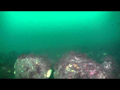
On the northern edge of NOAA's Stellwagen Bank National Marine Sanctuary, rocky ridges on the southern edge of Jeffreys Ledge rise to within 115 feet of the surface. The shallowest portion of the ledge is comprised of piled cobble and boulders. Anemones, stalked tunicates, and coralline algae reside on the rocks making for a colorful landscape when illuminated with a dive light. The ledge’s piled boulders create a complex structure with many crevices for marine fishes like cusk and wolffish.
For more information visit: http://stellwagen.noaa.gov/visit/diving/diving.html
English (vertaal deze tekst in Nederlands): On the northern edge of NOAA's Stellwagen Bank National Marine Sanctuary, rocky ridges on the southern edge of Jeffreys Ledge rise to within 115 feet of the surface. The shallowest portion of the ledge is comprised of piled cobble and boulders. Anemones, stalked tunicates, and coralline algae reside on the rocks making for a colorful landscape when illuminated with a dive light. The ledge’s piled boulders create a complex structure with many crevices for marine fishes like cusk and wolffish.
For more information visit: http://stellwagen.noaa.gov/visit/diving/diving.html
 Comments
login om dit tool te gebruiken.
Nog geen account? Registreer eerst; it's free!
Alle tonen (0)...
Wees de eerste en becommentarieer dit land
Fouten, Feedback
Je kunt deze pagina gebruiken om fouten te herstellen of nieuwe info toe te voegen. Als je problemen hebt met deze pagina, Stuur ons feedback.
Wannadive.net 24/24
Wannadive.net op jouw mobiel

Nieuwsbrief Alle nieuws per E-mail
 Jeffreys Ledge